
Keep in mind that the Su-34 had just entered service last 2014, so you’d think that they’d be upgraded with some sort of a functional navigation system. More so, they’re going up against Ukraine’s MiG-29s, which were initially introduced in Russia in 1982.
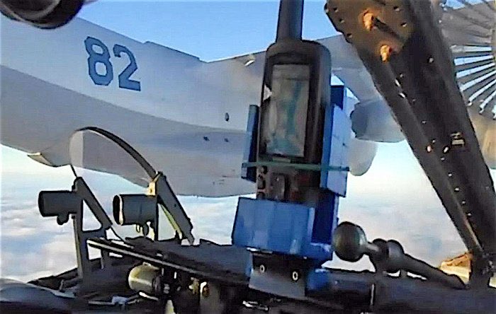
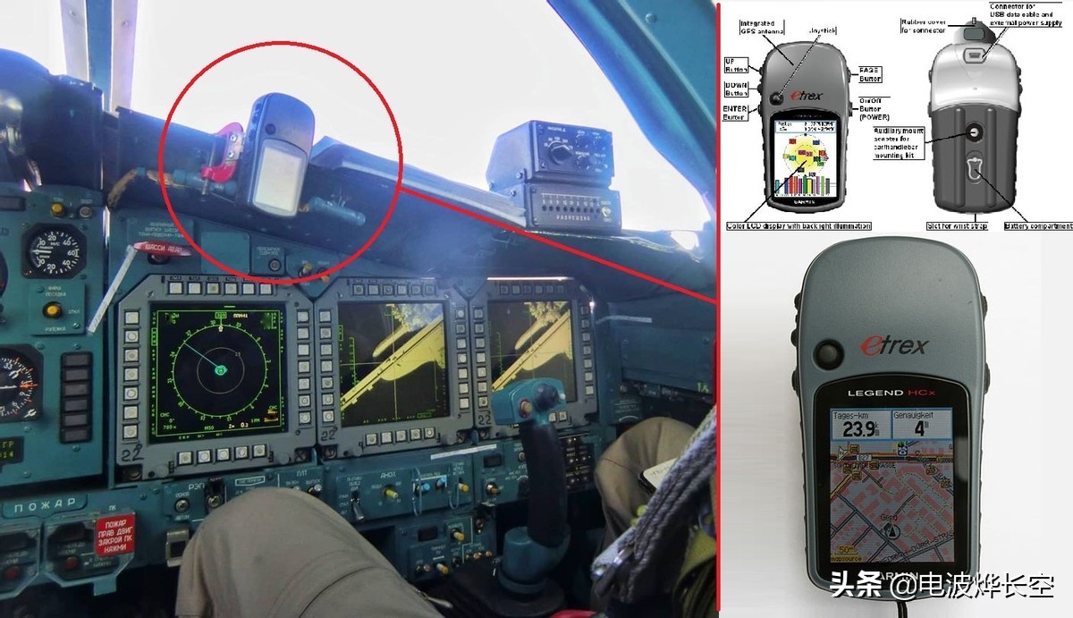
Believe it or not, this is not the first time the Russian Air Force has been found with this rudimentary GPS. During their intervention in Syria, it was found that the Su-34’s cockpit had already been using commercial GPS receivers, which exposes the fact that the Russian had been encountering this problem for years without addressing it. The GPS was later identified to be a Garmin brand GPS.
Last year, Russian Nationalist Politician and Soviet Air Force veteran Viktor Alksnis pointed out that these Garmin GPSs were merely just attached to the dashboard with a clamp and that it was just “an ordinary tourist satellite navigator sold in any electronics store.”
“This is a popular travel navigator Garmin eTrex Venture HC worth about 10,000 rubles,” Alksnis stated.
According to Garmin, their navigation system is frequently used by aviation enthusiasts as the eTrex Legend can locate positions quickly, shows the weather, and has a terrain warning service. Perhaps best of all, it has a European database and thus, is very suitable for European use. The same can be said for the Garmin GPSMAP 496, which was seen on the dashboard of a Su-25SM3.
However, this raises the question, “What navigation systems are they using on their aircraft?”
Both the Su-34 and Su-25SM3 were reported to have their own satellite systems. The Su-25SM, the original variant, was equipped with A-737-01 GPS and GLONASS dual-signal satellite navigation receiver. The new Su-25SM3 was also reported to have upgrades such as changing the satellite navigation receiver to PPA-S /V-06, also compatible with GPS and GLONASS dual signals, adding the ability to edit waypoints.
GLONASS is a system of 24 satellites capable of full global coverage with an accuracy of 5-10 meters vertical positioning dating back to the early 1980s. On the ground, the service is controlled via a single system control center, 5 telemetry, tracking and command centers, 2 laser ranging stations, and 10 monitoring and measuring Stations. Ukraine was also using the GLONASS system prior to the invasion.
After the war began, Ukrainian hacker teams attacked the system and seemed to have crippled it requiring the Russians to switch to the Western GPS system.
On April 22nd, the Russians launched their new Angara 1.2 rocket with a military payload believed to be a radar-equipped satellite into low Earth orbit. The satellite failed to active upon being deployed.
Russian pilots who flew in Syria reported that their own GLONASS system was lacked the coverage to provide accuration positioning and they could only rely on GPS. Reports have also surfaced that the Russian GLONASS system and satellite constellation had been underfunded, so Russia had to build differential correction stations in Syria for their data to be more accurate by an astonishing 30% to 40%.
This lack of accurate global positioning would also explain to some extent the Russian reliance on unguided munitions as their lack of a working global positioning system would affect the guidance systems of these munitions.
In Ukraine, Russian units seem to be reliant on 1980s paper maps of Ukraine. We also know that their secure communications systems relied on cellular towers in Ukraine that the Russians destroyed to disrupt Ukraine military communications, crippling their own in the process. The Russian army was then compelled to use VHF/UHF frequencies that could be easily jammed and also triangulated for artillery and missile strikes.
When this war is over, a significant factor in the expected Russian defeat will be their inability to navigate and communicate to their aircraft and ground units.


COMMENTS