

Today, we’re going to jump into Land Navigation, one of the key areas that end up failing the majority of candidates who volunteer for Selection.
Many people who read our articles here in SOFREP have either just volunteered for a special operations school slot or have already done so and are either waiting for a class date or entering the military from Day 1 with Basic Training. For those interested in getting through the grind of the courses you’ll encounter, we strongly recommend that you follow our physical training (PT) program that will help you attain a level of physical fitness not just to pass the course but to excel. The 17-week physical fitness training program starts gradually and works your way up to where you should be ready to take it on. But today, we’re going to jump into Land Navigation.
Everyone who volunteers for Selection always has concerns and questions about rucking. We touch on that a few times every week in our PT program, and we’ll continually post rucking articles on the site that you’ll no doubt find helpful.
Part of the battle is the proper fitting of your boots and socks and dealing with basic foot care. It starts with the individual. Taking care of your feet is paramount in Special Operations, and if you do it properly, the road through selection and qualification will be much easier and less painful.
Land Navigation: The Hidden Dealbreaker
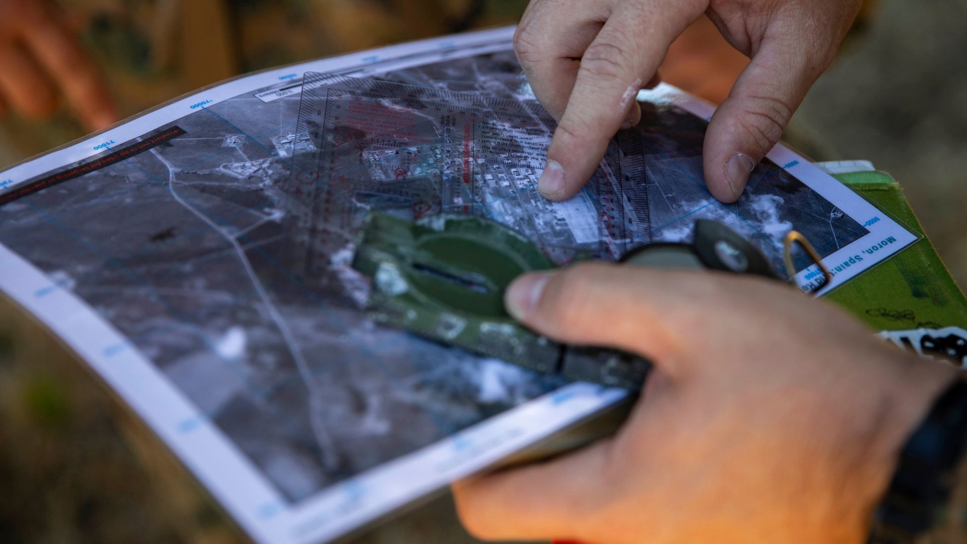
Land navigation is a critical skill for Special Forces candidates; failing it can derail your progress. There are two main culprits: the course itself and lack of preparation.
The Hoffman Challenge: The Hoffman, North Carolina course used in the Special Forces Assessment and Selection (SFAS) and the Special Forces Qualification Course (SFQC) is undeniably the most demanding land navigation test in the US military. It’s designed to push you, but remember, it’s not unbeatable.
Preparation is Key: Just like physical fitness, success in land navigation hinges on dedicated preparation. Here’s the good news: countless candidates have conquered this course before you, and countless more will follow.
Starting From Scratch: Similar to our PT program, we’ll break down land navigation into digestible steps, starting with the absolute foundation: map reading. Can you navigate confidently using a map, even in the dark? If not, we’ll equip you with the skills to excel.
No Military Base? No Problem.
While access to a military land navigation course is ideal, it’s not a dealbreaker. Numerous resources can bridge the gap:
- Military Resources: Abundant military manuals and study guides exist.
- Civilian Options: Civilian orienteering clubs offer classes and practical exercises, turning map-reading novices into experts. Most clubs welcome aspiring Special Operations candidates.
Seek Out Mentors
If you’re already in the military, tap into experienced NCOs and officers from Ranger, Airborne, or Light Infantry units. They often possess valuable land navigation skills and can address your specific challenges.
Master the Skill
Ultimately, strive for map reading and land navigation expertise – ideally reaching a level where you can confidently teach others. This mastery will give you a significant advantage at Selection.
For Civilians
While the path might be more demanding for civilians, don’t be discouraged. The resources mentioned above, coupled with dedication, can equip you for success.
Land Navigation Terms and Definitions
The skills and terms that you should be very familiar with include, but won’t be limited to:
- Contour Lines: what are contour lines? Know the 3 types and how they appear on the different terrain features. Also, know how to find and identify the contour interval on each map sheet
- Terrain Features: How many are there? Know how to be able to identify each
- Declination diagram: Identify it on the map and know how it works. Be able to immediately know what the declination is for your area.
- Azimuth and Back azimuth: Identify what it is, how it is used, and how to calculate it using the declination diagram. What are the two ways it can be measured?
- Orienting a Map: What is the definition of it? How many methods are there to do it and be able to do it using each way
- Intersection: What is it? How is it used? and most importantly, how is it determined
- Resection: What is it? What is it used for? And be able to do it easily
- Dead Reckoning: What is the definition? Know the steps that entail using it. (Many candidates use this exclusively, but not all accurately)
- Field Expedient Direction: How many ways are there to determine it? Be able to perform each one
- 8-digit Grid Coordinate: What does this measure? How close will that take you to a point on the ground?
- 6-digit Grid Coordinate: What does this measure? How close will that take you to a point on the ground
- Colors on the Map: How many are there, and what do they denote?
- Mils to degrees: How many mils equal one degree? How is each one used?
- Circle: How many mils? How many degrees?
These are just a sample of terms and skills that you’ll need to know in Selection. Scan the list above. Are you an expert (or very close to it) on each one of these skills? If the answer is no for any of them, then you aren’t ready for Selection and need to spend some time training. Even if you are, you should get in some good practice beforehand, especially if you haven’t done it in a while.
But There’s More to It

Essential Gear and Smart Practices
Don’t underestimate the importance of a good map case. Choose one that’s waterproof and allows marking with a grease pencil for notes. Secure it to your body with a dummy cord, alongside your compass and weapon. Losing your map is a guaranteed Selection failure, so be proactive!
Navigation Efficiency
Land navigation isn’t about elaborate tactics. Fold your map with the relevant area readily accessible. During map checks, mark your progress with a grease pencil for a quick reference on the next leg. Fumbling with an unfolded map under pressure wastes precious time.
Distance Tracking Made Easy
Consider Ranger beads to simplify distance tracking. Especially in dense terrain with multiple checkpoints, it’s easy to lose track. Beads offer a reliable way to stay on course.
We’ll dig deeper into these topics and apply them practically soon. Remember, asking questions is crucial – there are no dumb questions here!
**This article has been reviewed and updated by the SOFREP News Team.
—
Disclaimer: SOFREP utilizes AI for image generation and article research. Occasionally, it’s like handing a chimpanzee the keys to your liquor cabinet. It’s not always perfect and if a mistake is made, we own up to it full stop. In a world where information comes at us in tidal waves, it is an important tool that helps us sift through the brass for live rounds.


COMMENTS
There are on this article.
You must become a subscriber or login to view or post comments on this article.